Augmented reality is connecting a world of data for people who may not be familiar with GIS. 3D, AR and VR are the next big thing in the GIS industry
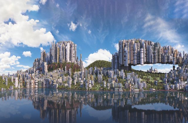
Far from merely being cool, three-dimensional models have all sorts of applications, from planning and analysis for anything from urban development to understanding where to send first responders in the event of an emergency. When three-dimensional modeling can be fused with virtual reality or augmented reality, it is even easier for people to understand what they are seeing.
AR and VR
Siggraph Booth Graphic klein
Let’s start with some basics: what is virtual reality? Virtual reality means creating a computer image of the real world. VR helps people to understand what could be possible by combining both things that are real — a 3D model of a downtown using geographic data — and not yet real — a 3D model of a proposed building. The building model can be placed into the existing 3D urban location to see what the proposed building will look like in the real space.
Augmented reality is different: it involves placing an image on a picture of the real world. An example of AR could be officials bringing up an image of a building that is on fire and overlaying a schematic so they can direct those first responders to fire escapes and rooms within the building.
The next big thing
Think about last year’s craze, Pokemon, a game on a phone. It helped introduce the concept of merging real-life maps and information with things that don’t exist in our real space. AR is now opening up the entire field of GIS to people who might not be keen on geography or mapping.
AR and VR
CityEngine 2016.1 feat ArcGIS 360 VR
I think 3D, AR and VR are the next big thing in the GIS industry. Take for example, a project led by the Fraunhofer Institute that Esri Deutschland GmbH is engaged in called Morgenstadt — City of the Future. The project uses 3D technology and VR to work on predicting, developing and implementing innovations for tomorrow’s cities. Esri technology is being used to generate 3D urban models, a key planning tool for towns and cities, which can be used in conjunction with AR and VR to make the planning process more transparent. Simulations of the spread of noise/pollutants or of areas exposed to the sun or in the shade help workable, sustainable decisions to be reached. Using these models along with AR and VR opens up the innovative involvement of city dwellers and creates a real-time experience.
It isn’t just a futuristic vision — this can be applied today in your work environment. Maybe oil workers have a tough time laying pipe in a remote location. They might not necessarily know what a coordinate is, but what if you could draw a red ‘X’ on the spot where the pipe should go? What if you could shade an area in red that is dangerous for them to go into, or the land in that area is owned by another entity and they need to be careful not to lay pipe in this area?
What about finding a hidden asset, like a pipe or valve in that remote location — when the field is covered in snow? Using AR, the exact location can be immediately understood and found, without spending five hours shovelling snow.
Another example could be city and county governments and how they deal with building encroachments. Managing right of ways is tough. Today, a surveyor is sent out to measure the structures that are being built in someone’s backyard to ensure they do not go into the right of way. This is expensive and can take a long time. Many cities do not employ a lot of surveyors to handle this and they have many jobs. What if, instead, a surveyor could dispatch an intern to go take a picture, impose that picture into the GIS data and check for encroachment? The surveyor can go later to check projects that are questionable, but AR technology can very quickly ease the work burden and save the city or county — and ultimately you, the tax payer, money. Connecting a world of data like this for people who may not be familiar with GIS is really powerful. And AR is making this happen.
The field is so new
I liken the technology and hardware to the evolution of how we listen to music when we are on the go. Remember the DiscMan? We have come a long way since then! And that’s where I see this exciting realm in 3D technology.
As the business lead for Esri CityEngine, 3D and Geodesign, I am excited to be in the middle of all of this. Esri CityEngine is a standalone software product that provides users with a unique conceptual design and modeling solution for the efficient creation of 3D cities and buildings. The creation of 3D urban scenes based on existing GIS data is one of the key strengths of CityEngine. You can create high-quality 3D content using nothing more than a combination of 2D data, attributes, and procedurally defined rules. This means that any GIS organization can create 3D urban environments using the data they already have. These environments can then be easily shared on Esri’s cloud solution, ArcGIS Online.
AR and VR
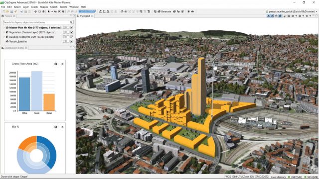
CityEngine 2016 – Design buildings by numbers
The latest version of CityEngine, just released at the end of last year was a real gamechanger and allows urban planners, architects, and GIS professionals to simply and quickly create VR experiences on mobile devices. These experiences can be viewed in a free ArcGIS 360 VR app that is available from Esri Labs. Users can immerse themselves into 3D scenes by teleporting to static viewpoints and comparing different urban planning scenarios.
The City of Zurich, the most sustainable city in the world, uses ArcGIS 360 VR so that their planning board and jurors can study the impact of new architectural developments and urban planning scenarios from the perspective of pedestrians and citizens.
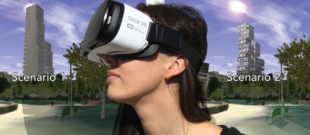
Esri CityEngine can create content for high-performance VR headsets such as the Oculus Rift, but it can also be used with a simple smartphone paired with the Samsung Gear VR headset. A mobile VR solution like this provides an immersive experience quickly and can be viewed on a connected mobile device as well as offline.
VR experiences like this are similar to Google’s Streetview, providing the ability to look around from a static viewpoint and teleport to another panorama. Creating a VR experience like this is good for simplicity’s sake. Creating a 6 degrees of freedom VR experience, where the operator can move around, is still a complicated task requiring expert knowledge with 3D tools, data simplification and optimization, real-time rendering or game engines, and graphics hardware. A big driver behind ArcGIS 360 VR was to create a one-click-publish-to-VR user experience for 3D scenes.
The City of Zurich, the most sustainable city in the world, uses ArcGIS 360 VR so that their planning board and jurors can study the impact of new architectural developments and urban planning scenarios from the perspective of pedestrians and citizens
That being said, Esri is constantly working on new R&D projects, including real 3D VR technology for use with full 6DOF VR immersion. With any of these new “realities”, the power lies in enabling people to understand what they are seeing.
Author:
